Mudflats and Salt Marsh: vital habitats, and effective flood defence
Coastal salt marsh and mudflats are vital habitats and effective flood defences - it's official!
The Department for Environment, Food and Rural Affairs (Defra) has launched its first major wetlands creation project at Wallasea Island in Essex, aiming to ensure the survival of Coastal Salt Marsh and Mudflats as internationally important habitats and as the most effective and sustainable form of flood defence for the local human population.
Defra said this week that 'Wetlands, including salt marsh and mud flats, are some of the last natural wilderness areas left in England.
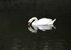
They provide breeding and roosting places for important bird species, as well as habitat for rare plants, insects and fish. They are also breeding and nursery areas for aquatic wildlife, such as bass, mullet, flatfish and herring.
They act as buffer zones that absorb wave energy and protect the coast from storm damage and flooding.' (see Defra and wetland habitats )
Inappropriate developments such as the Cardiff Bay barrage have ensured that such wetland provision in Britain has been significantly depleted - inappropriate developments which clearly must cease if we are to ensure the survival of these unique habitats and the wider ecosystem they support and protect.
To create the UK's largest man-made (or sea-reclaimed!) marine wetland to date, on 4th July 2006 the sea defences at Wallasea Island were deliberately breached and by the evening, 'the sea was covering 115 hectares of former wheatfields, which from now on will be saltmarsh and mudflats on which migratory wildfowl and wading birds can find shelter. It will also improve flood defences, provide for better fish nurseries, and create opportunities for recreation, said officials from Defra.
Barry Gardiner, the Government's Biodiversity Minister said: "Saltmarsh is rarer than rainforest and is important to people, particularly as a flood and storm defence, and to wildlife. Hundreds of thousands of wetland birds rely entirely on the Essex saltmarsh for their food each winter".
"The wetlands will also provide additional flood and storm protection. Damaging storm waves lose their energy as they pass over the area, and the new sea defences will provide better protection than the old ones, which were in very poor condition," Mr Gardiner added. (see The Independent)
Mud, mud, glorious mud!
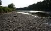
Salt marsh and mudflats are a vital and internationally important habitat, supporting diverse species from invertebrates upwards through the foodchain. The Ribble's mud forms the basis of its intertidal ecosystem, which supports numerous bird species (over 1/4 million birds every year) and fish species including Atlantic Salmon, the 10th most threatened animal species in Europe - and these mudflats and salt marsh dissipate wave energy, thus reduce the risk of flooding to the low-lying land along the Ribble corridor.
Both salt marsh and mudflats are UK Priority Biodiversity Action Plan habitats, and are at risk from inappropriate developments such as barrages and from sea level rises. In view of sea level rises alone, the onus is on creating more of these vitally important areas just to maintain the status quo.
English Nature, Defra, and other organisations and Government bodies are working to protect and enhance mudflat and salt marsh habitat provision.
English Nature's Biodiversity Action Plan (BAP) for mudflats and salt marsh estuarine habitats states that human 'land claim... has removed about 25% of Great Britain's estuarine intertidal flats and up to 80% in some estuaries...
'Many other factors affect/will affect this habitat, e.g. sea level rise, barrage schemes, discharges from agriculture, industry and urban areas...
'As with most marine habitats, the best form of management is prevention of damage as little can be done to help the habitat be restored.'
The BAP map and the Ribble mudflats...
English Nature's Biodiversity Action Plan map of the Ribble shows its areas of UK Priority habitat mudflats - including those which run right into the centre of Preston and South Ribble, as far as Frenchwood and Walton le Dale as well as Penwortham - as well as other UK Priority BAP habitats in the Ribble area including Coastal and Flood Plain Grazing Marsh areas such as the Penwortham/Walton le Dale green belt, Fishwick Bottoms, and Lower Brockholes...
Read more about the wildlife supported by coastal salt marsh and mudflats.
The Government's £7.5m Wallasea Wetlands Creation Project is an example of "managed realignment" - coastal engineering to accommodate the sea-level rise that is being brought about by global warming.
Essex originally had 35,000 hectares of saltmarsh but enclosure for agriculture and development over many years has destroyed much of that habitat. Only 2,000 hectares remain, including the newly recreated Wallasea Island wetland.
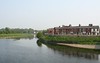
Just to put this into perspective, the Ribble Estuary SSSI (Site of Special Scientific Interest) is 9,226 hectares (22,798 acres) of combined mudflats, sandflats, and salt marsh. This is what makes the Ribble Estuary the 2nd most important wetland site in the UK, protected under the International RAMSAR wetlands convention, and a designated Special Protection Area under the EU Birds Directive and the UK Conservation (Habitats &c) Regulations 1994.
The Ribble's wetland habitat is a dynamic system which changes, but comprises approximately 20% saltmarsh and 80% mudflats and sandflats. 6,730 hectares of this habitat are in Lancashire and 2,501 hectares in Merseyside.
This estuarine wetland habitat is created and supported by the free-flowing tidal nature of the Ribble. Any changes in the free-flow of water, silts and nutrients - such as a Ribble barrage would cause - would put this internationally important habitat at risk, and deplete its flood defence capabilities.
Sustainable habitat and sustainable communities.
The new Wallasea Island wetland creation will be a huge tourist attraction, will help to mitigate the effects of wetland depletion caused by sea level rises and previous developments on this vital and protected habitat, and provides the area with an effective flood defence, being 115 hectares and costing a modest £7.5m... a drop in the ocean compared to the £914 million (at last estimate) for Riverworks (Lancashire Economic Strategy), at least £60 million of which is for the barrage alone (see Riverworks 01: Quality Riverside)...
Sustainability is the key, as the cost of the Wallasea Island saltmarsh and mudflat habitat creation is even more impressive when we reflect on the £20+ million the Welsh Assembly have to fork out EVERY YEAR to try to address the environmental problems the Cardiff Bay Barrage has created for the environment and local communities, including water quality problems in the impounded river basin and rising water levels underneath people's homes.
On top of this, the £10 million it cost to create the supposed "alternative habitat" for wildlife near Cardiff - in order to try to mitigate some of the effects of the loss of the tidal habitat in Cardiff's Bay of Tigers - has been wasted as the majority of the birds displaced by the Cardiff Bay barrage have not turned up there... see The Real Price of the Cardiff Bay Barrage.
The RSPB are currently aiming to reclaim a section of Coastal Salt Marsh from farmland at Hesketh Out Marsh just downriver from Preston. This will ensure that this vitally important wetland habitat in the Ribble Estuary is at the very least maintained against sea level rises, and will contribute further wetland flood defences for communities along the Ribble over the coming decades.
As sea levels rise and rainfall continues to increase in Lancashire, we will hopefully see more salt marsh recreation on the Ribble Estuary to offset the risk of flooding to communities along the Ribble corridor and the threat to wildlife through loss of habitat to the sea, creating a massive draw for tourism at the same time as providing effective, and both environmentally and economically sustainable flood defence measures...
... as well as implementing Government Policy...
DEFRA's policy is to promote the further (re)creation of salt marsh and mudflat habitats, and the Environment Agency is required under the terms of the Biodiversity Action Plan to create 2,000 hectares of new habitat every year at the same time as ensuring that no habitats are lost through flood risk management projects , and have established the Regional Habitat Creation Programme to implement this.
In Lancashire, we now have our own Biodiversity Action Plan, and you can view the draft document on salt marsh on the Lancashire Biodiversity Action Plan website.
You can read more on Coastal Saltmarsh and mudflats and their vital importance to wildlife and human communities on the RSPB website.
Contact us on savetheribble@tiscali.co.uk
Labels: biodiversity, mud, saltmarsh, silt, wetlands
posted by Reigh Belisama @ 3:12 pm
![]()
![]()


1 Comments:
Please tell me where the proposed Ribble Barrier is planned for
annonymous
Post a Comment
<< Home